


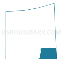
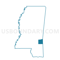
State Line Voting District, Wayne County, Mississippi
About
Outline

Summary
| Unique Area Identifier | 606912 |
| Name | State Line Voting District |
| County | Wayne County |
| State | Mississippi |
| Area (square miles) | 55.43 |
| Land Area (square miles) | 54.69 |
| Water Area (square miles) | 0.74 |
| % of Land Area | 98.66 |
| % of Water Area | 1.34 |
| Latitude of the Internal Point | 31.47801690 |
| Longtitude of the Internal Point | -88.52888080 |
Maps

Graphs
Select a template below for downloading or customizing gragh for State Line Voting District, Wayne County, Mississippi


Neighbors
Neighoring Voting District (by Name) Neighboring Voting District on the Map
- Buckatunna Voting District, Wayne County, MS
- Chicora Voting District, Wayne County, MS
- Laton Hill Fire House Voting District, Washington County, AL
- Piave Voting District, Greene County, MS
- State Line Voting District, Greene County, MS
- Yellow Pine Voting House District, Washington County, AL
Top 10 Neighboring County Subdivision (by Population) Neighboring County Subdivision on the Map
- Chatom CCD, Washington County, AL (4,321)
- District 1, Wayne County, MS (3,769)
- Millry CCD, Washington County, AL (2,775)
- Fruitdale CCD, Washington County, AL (2,543)
- District 3, Greene County, MS (2,408)
- District 2, Greene County, MS (2,057)
Top 10 Neighboring Place (by Population) Neighboring Place on the Map
Top 10 Neighboring Unified School District (by Population) Neighboring Unified School District on the Map
- Wayne County School District, MS (20,747)
- Washington County School District, AL (17,581)
- Greene County School District, MS (14,400)
Top 10 Neighboring State Legislative District Lower Chamber (by Population) Neighboring State Legislative District Lower Chamber on the Map
- State House District 65, AL (38,681)
- State House District 105, MS (24,574)
- State House District 86, MS (21,915)
Top 10 Neighboring State Legislative District Upper Chamber (by Population) Neighboring State Legislative District Upper Chamber on the Map
Top 10 Neighboring 111th Congressional District (by Population) Neighboring 111th Congressional District on the Map
Top 10 Neighboring Census Tract (by Population) Neighboring Census Tract on the Map
- Census Tract 9501, Greene County, MS (8,092)
- Census Tract 9504, Wayne County, MS (5,215)
- Census Tract 440, Washington County, AL (4,321)
- Census Tract 439, Washington County, AL (2,775)
- Census Tract 443, Washington County, AL (2,543)
Top 10 Neighboring 5-Digit ZIP Code Tabulation Area (by Population) Neighboring 5-Digit ZIP Code Tabulation Area on the Map
- 39367, MS (15,096)
- 39476, MS (7,582)
- 36558, AL (3,854)
- 39362, MS (2,866)
- 36518, AL (2,842)
- 39322, MS (1,882)